2.1. Principle of map tiles#
What is tile? A tile is a collection of pictures in a grid that are similar to tiles. Tile data is a cache image set formed by pre-processing vector or image data and using efficient caching mechanisms (such as pyramids). It is organized in a “level, row, column” way, and can be quickly loaded in the web page. Therefore, tile map loading is to obtain the tiles of the grid under the corresponding level (i.e. the image pre cut by the server) by calculating the row and column number according to the map range and level requested by the client, and these tiles are collected to form a map at the client, as shown in Figure 2.21.
Vector map and tile map have their own characteristics and advantages, and they can be applied in combination. The real-time generation of vector map can edit, query and analyze the map data online. it has spatial relationship and can support network analysis, spatial analysis and other applications. Because the tile map is a pre-cut cache picture collection, the network loading speed is fast and the effect is good, so it is often used as the base map.
Map slicing: the process in which the pre-generated method is stored on the server, and then the corresponding map tiles are sent to the client according to different requests submitted by the user. It is a multi-resolution hierarchical model, from the bottom of the tile pyramid to the top, the resolution is getting lower and lower, but the geographical range remains the same.
Map cache: Also known as map tiles, it is a directory containing map tiles of the entire map range at different scales, that is, a cached map service is a service that can use static images to quickly provide maps.
Here is an introduction to several important concepts in map slices.
2.1.1. Principle#
Several concepts:
In map slicing, there are three important concepts: 1. slice origin; 2. slice resolution (scale); 3. initial slice range. The following is a brief introduction to these three concepts.
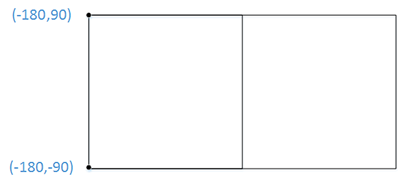
Map slicing schematic diagram#
1.Slice origin
There are generally two types of slice origins: 1. the upper left corner; 2. the lower left corner. Most of the slicing algorithms use the upper left corner as the origin of the slice, such as Sky Map, ArcGIS Server, and so on. The slice origin defines the location of my first 256*256 slice.
2.Slice resolution (scale)
The slice resolution and scale correspond one to one. Scale refers to the actual distance represented by a unit on my map. The resolution represents the actual distance represented by one pixel on the screen, so when one is determined, the corresponding one is also determined.
The slice resolution (scale) affects the actual coordinates of one of my 256-256 images at that resolution (scale).
3.Initialize the range of slices
The initial slice range refers to the size of the image I sliced, and the image is how many 256*256 slices I can slice at this resolution.
2.1.2. Map tiles technique#
After understanding the principle of map slicing, we will find that as
long as the relevant parameters (origin, resolution) are passed to the
map server, through the GetMap You can get the slice. Of course, in
the specific technical implementation, we still have to do some
calculation, traversal and other operations.
To get a slice, you can see the previous section. GetMap The example
illustrated in.
2.1.3. Map tiles software tool#
After the emergence of the concept of map slicing, many software tools for map slicing have been developed. On the one hand, the original GIS software added the function of map slicing; on the other hand, some independent map slicing tools have been developed.
On the Python side, TileCache was used earlier, but the last version of this tool ( tilecache-2.11 ) was released in October 2010 and has since been discontinued. TileCache is an implementation of a WMS-C (about) compliant service released by Metacarta under the BSD license. (and TileCacheConfig) TileCache originated from a resolution at the FOSS4G 2006 conference, which was a later OGC recommendation, the WMS Tiling Client Recommendation. The so-called TileCache is because the ordinary WMS server needs to read data and generate pictures after receiving the request, and the efficiency is too low. Then for those immutable map services, you can encapsulate a TMS (Tiled Map Service) in the front end of WMS. TileCache first caches some WMS map images, provides a pseudo WMS, and only interacts with the background WMS server when appropriate. The implementation of this standard is provided by MetaCarta, the backend of OpenLayers, called TileCache. TileCache is implemented in Python and can be deployed and run on Apache and IIS as well as Python’s WSGI via cgi.
TileCache provides a Python-based WMS-C/TMS service with a pluggable caching mechanism and rendering backend. In the simplest use case, TileCache only needs write access to the disk, the ability to run Python CGI scripts, and the WMS to cache. With these resources, you can create your own local disk-based cache for any WMS server And use this result in any client that supports WMS-C, such as OpenLayers, or any client that supports TMS, such as OpenLayers and WorldKit.
MapProxy is another map slicing tool developed in Python language after TileCache. Its degree of perfection is much greater than TileCache, and the current development is still very active.
2.1.4. Tools for maps tiles#
When the user browses the system map, MapServer parses, draws and cuts the image according to the MapFile file in real time and returns the image to the client. The response time is acceptable when there is a small amount of local data, but when the amount of local data is large and accessed by a large number of users, the response time will be unbearable. This topic will use the open source tilecache technology to realize the map tile cache, and use the cache mechanism to improve the response efficiency of the system.
The idea of map tile comes from the hierarchical detail model, which can cut the whole image into a large number of small images with the same resolution. When users view the image, generally only a small number of tiles are operated at a time, and the server can send the corresponding tiles to meet the needs of users. In this way, while reducing the amount of network data and reducing the bandwidth, the use of Ajax technology to make tiles download asynchronously on the server can greatly reduce the system response time and improve the user experience.
The map tiles are organized and stored in groups according to proportion by pyramid structure (quadtree). For each increase in the browsing level, four images with higher resolution are used instead of one with lower resolution.
Each tile in the pyramid model is given a unique ID number. Using the numbered index, combined with the resolution required by the user to operate the map, we can determine which numbered tile is needed.
tilecache is a map tile buffer developed by MetaCarta Labs, which is used to cache maps. Only when the requested map is not in the tilecache buffer file, will it interact with the service to request the map (Li Zhenhua, Liu Peng, Wang Zhen, & Gao Chengxia, 2009), with OpenLayers to make map display faster. Tilecache supports multiple OGC service standards and multiple servers, and supports multiple request formats and methods.
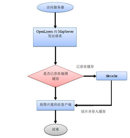
Tilecache caching mechanism#
Tilecache caching mechanism
MapCache is a server that implements tiled caching to speed up access to the WMS tier. The main goal is to be fast and easy to deploy, while providing basic functionality (and more! Map slice caching solution
MapProxy is a map slicing tool developed by Python. It is easy to use and stable in production environment.